By Roland Piquepaille
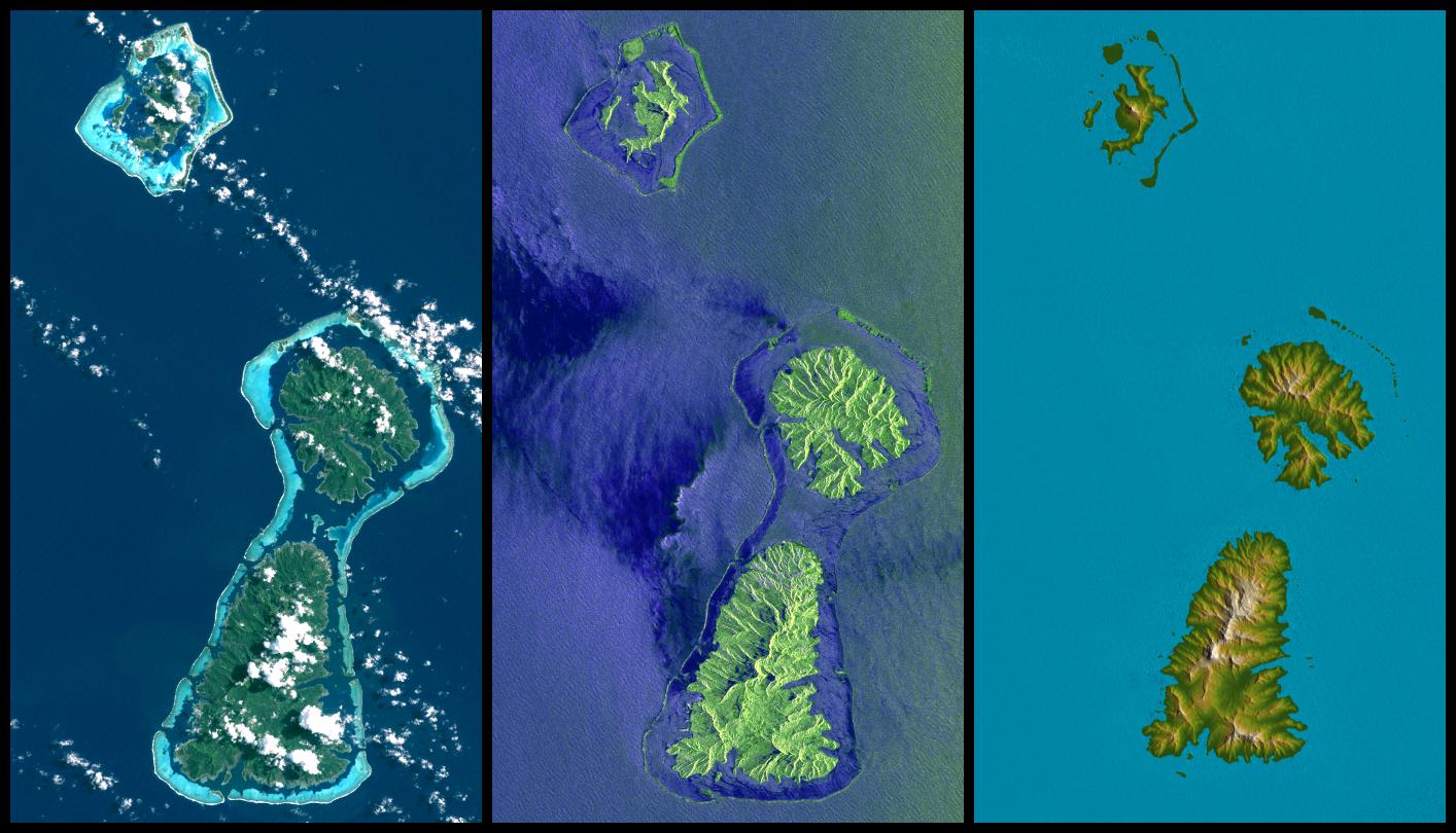
It took four years to NASA and the National Geospatial-Intelligence Agency (NGA) to fully process the data gathered during the Space Shuttle Endeavour Radar Topography Mission (SRTM) in February 2000. Unlike previous Earth's maps, this one shows "detailed swaths of Earth's topography previously obscured by persistent cloudiness," according to NASA News. The latest images delivered by NASA include Australia, New Zealand and many islands in the South Pacific. NASA adds that these new maps are vital to mitigate "the effects of future disasters such as the Indian Ocean tsunami." I don't really know if this statement is true. Mother Nature is certainly stronger than NASA. Anyway, don't miss this fly-around movie above New Zealand (Quicktime format, 2 minutes, 6.42 MB). Read more...Below are three images of the islands of Bora Bora, Tahaa and Raiatea, French Polynesia (top to bottom) taken from space (Credit: NASA/JPL/NGA). Here are two links to more details and to a larger version of these images.
This display compares three differing "views from space" of these islands. On the left, an image from the Landsat 7 satellite shows the islands as they might have appeared to an astronaut in orbit in 1999 (but a little sharper and with atmospheric haze suppressed). In the middle is an image created from data gathered by the third-generation Shuttle Imaging Radar (SIR-C), flown in 1994. On the right is a graphic illustrating elevation data gathered by the Shuttle Radar Topography Mission (SRTM) in 2000.

The Landsat satellite cannot 'see' through clouds, almost always present on this kind of islands, while the SIR-C shows the waves and other effects of winds upon the ocean surface. But the STRM shows a detailed elevation model and can help to in understand and interact with our environment.
After watching these local images, it's time to look at the big picture. Here is what NASA News says about this new Earth's map.
The digital elevation maps encompass 80 percent of Earth's landmass. They reveal for the first time large, detailed swaths of Earth's topography previously obscured by persistent cloudiness. The data will benefit scientists, engineers, government agencies and the public with an ever-growing array of uses.
"This is among the most significant science missions the Shuttle has ever performed, and it's probably the most significant mapping mission of any single type ever," said Dr. Michael Kobrick, mission project scientist of NASA's Jet Propulsion Laboratory, Pasadena, Calif.
According to NASA, this technology could also be used for space exploration.
SRTM data are being used for applications ranging from land use planning to "virtual" Earth exploration. "Future missions using similar technology could monitor changes in Earth's topography over time, and even map the topography of other planets," said Dr. John LaBrecque, manager of NASA's Solid Earth and Natural Hazards Program, NASA Headquarters, Washington.
Sources: NASA News, January 6, 2005; and various NASA websites
Related stories can be found in the following categories.
Famous quotes containing the words earth, extensive, global and/or map:
“I am quite serious when I say that I do not believe there are, on the whole earth besides, so many intensified bores as in these United States. No man can form an adequate idea of the real meaning of the word, without coming here.”
—Charles Dickens (1812–1870)
“In an extensive reading of recent books by psychologists, psychoanalysts, psychiatrists, and inspirationalists, I have discovered that they all suffer from one or more of these expression-complexes: italicizing, capitalizing, exclamation-pointing, multiple-interrogating, and itemizing. These are all forms of what the psychos themselves would call, if they faced their condition frankly, Rhetorical-Over-Compensation.”
—James Thurber (1894–1961)
“However global I strove to become in my thinking over the past twenty years, my sons kept me rooted to an utterly pedestrian view, intimately involved with the most inspiring and fractious passages in human development. However unconsciously by now, motherhood informs every thought I have, influencing everything I do. More than any other part of my life, being a mother taught me what it means to be human.”
—Mary Kay Blakely (20th century)
“You can always tell a Midwestern couple in Europe because they will be standing in the middle of a busy intersection looking at a wind-blown map and arguing over which way is west. European cities, with their wandering streets and undisciplined alleys, drive Midwesterners practically insane.”
—Bill Bryson (b. 1951)